Geography for Geographers
  • Home
  • Geography Resources for Teachers
    • Geographic Information Systems Resources
    • Global Studies Resources
    • Human Geography Resources
    • World Geography Resources
  • Incorporating GIS into 9-12
    • GIS in a STEM Curriculum >
      • GIS&T Modules
  • Topics in Geography
    • Examining the Arctic: Iceland >
      • Examining the Arctic: Blog
    • Geographic Inquiry >
      • Field Data Collection
    • Modern Germany
    • Teaching Global Competence >
      • TGC Resources
    • Topics in African Geography
  • Presentations
    • An Introduction to GIS
    • GIS in the Classroom
    • Government Geoinquiries
    • Hands on GIS
    • Intermediate/Advanced GIS for Teachers
    • Making your Maps Work for You - Whats Next?
    • Mapping Nebraska
    • Preparing Students for GIS Careers
    • Teaching GIS in a STEM Curriculum
    • Traveling as a Teaching Tool
    • Using Geospatial Technologies to Teach Soil Conservation
    • Using Geospatial Tools as a Technological Aid
    • What are Nebraska Teachers Doing with GIS in Their Classrooms?
  • Mission

Making your maps work for you

Whats Next?!?

Your students have developed a plan, collected data, and completed some basic analysis. What’s next? Join this session to learn some tips, tricks, and ideas to visualize and present geographic data. Get your students to start thinking about how they can get geographic data working to answer questions and start purposing solutions. 
Human Development Index by Country (Example Map)
Human Development Index Dashboard Example
Making Your Maps Work For You (Presentation)
File Size: 843 kb
File Type: pdf
Download File

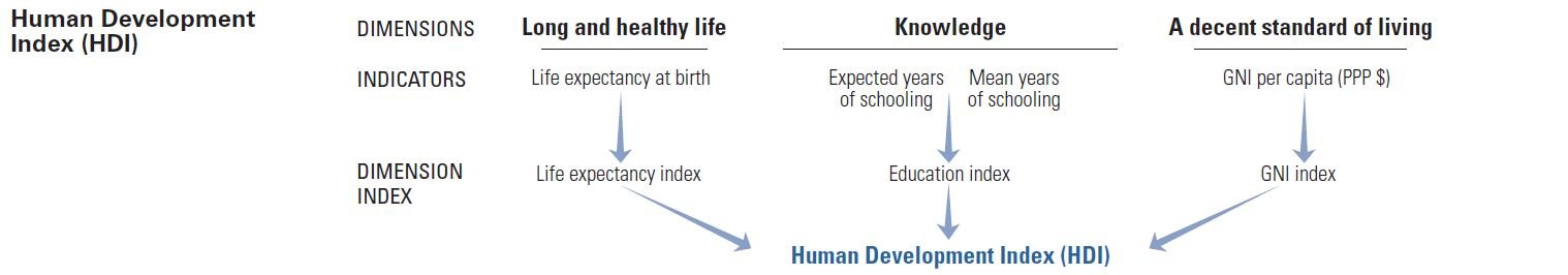
Demonstration (Making Maps to Learn the HDI)

Picture
Human Development Report (Technical Notes)
File Size: 293 kb
File Type: pdf
Download File

Human Development Index (csv table)
File Size: 9 kb
File Type: csv
Download File

Instructions for Using AGOL - Adding a Layer
File Size: 427 kb
File Type: pdf
Download File

Interpreting the HDI:
Very High Human Development - 0.800 and Above
High Human Development - 0.700-0.799
Medium Human Development - 0.550-0.699
Low Human Development - Below 0.550
Picture
Possible Connections:
- Geography of Industry and Development
- Population Geography
- Economic Geography
- World History
- Macro-Economics
- Global Studies
- World Geography
- Political Geography 

Sources:
United Nations Development Programme - Human Development Reports
Picture
Picture
Sites published and maintained by Kyle Tredinnick
Picture
  • Home
  • Geography Resources for Teachers
    • Geographic Information Systems Resources
    • Global Studies Resources
    • Human Geography Resources
    • World Geography Resources
  • Incorporating GIS into 9-12
    • GIS in a STEM Curriculum >
      • GIS&T Modules
  • Topics in Geography
    • Examining the Arctic: Iceland >
      • Examining the Arctic: Blog
    • Geographic Inquiry >
      • Field Data Collection
    • Modern Germany
    • Teaching Global Competence >
      • TGC Resources
    • Topics in African Geography
  • Presentations
    • An Introduction to GIS
    • GIS in the Classroom
    • Government Geoinquiries
    • Hands on GIS
    • Intermediate/Advanced GIS for Teachers
    • Making your Maps Work for You - Whats Next?
    • Mapping Nebraska
    • Preparing Students for GIS Careers
    • Teaching GIS in a STEM Curriculum
    • Traveling as a Teaching Tool
    • Using Geospatial Technologies to Teach Soil Conservation
    • Using Geospatial Tools as a Technological Aid
    • What are Nebraska Teachers Doing with GIS in Their Classrooms?
  • Mission